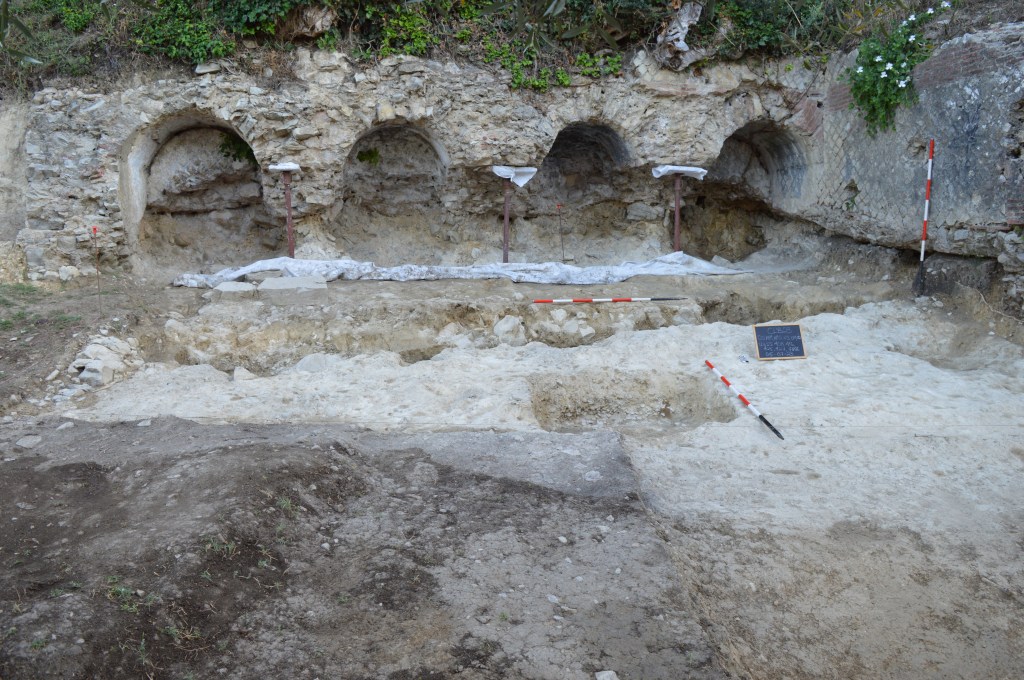
Excavations on the south side of Castiglione del Lago, below Via Belvedere, began in 2023. The presence of Roman structures below the Medieval walls of the town has long been known due to the visible remains of an arched structure with four niches oriented east-west and an adjacent water channel that runs from north to south. These structures are familiarly called “Le Buccace” by local residents. The opus mixtum technique visible on both structures dates their construction to ca. A.D. 100 (Fig. 1).
Archaeologists and historians have long postulated that there must have been an Etruscan and subsequent Roman settlement on top of Castiglione del Lago given its position overlooking the lake. To the east of “Le Buccace,” there is an Etruscan necropolis of the Hellenistic period, that was discovered in the early 2000’s during construction work (see tomb page). Scattered finds around Castiglione del Lago indicate other Etruscan burials but no evidence of a settlement. Excavations conducted inside the Rocca (2014) found no evidence of occupation on top of Castiglione del Lago prior to the Medieval period. It is also notable that none of the Medieval or Renaissance structures in the center of Castiglione del Lago show evidence of having reused Roman building materials and no Latin inscriptions have been found in or around the town itself (Fig. 2).
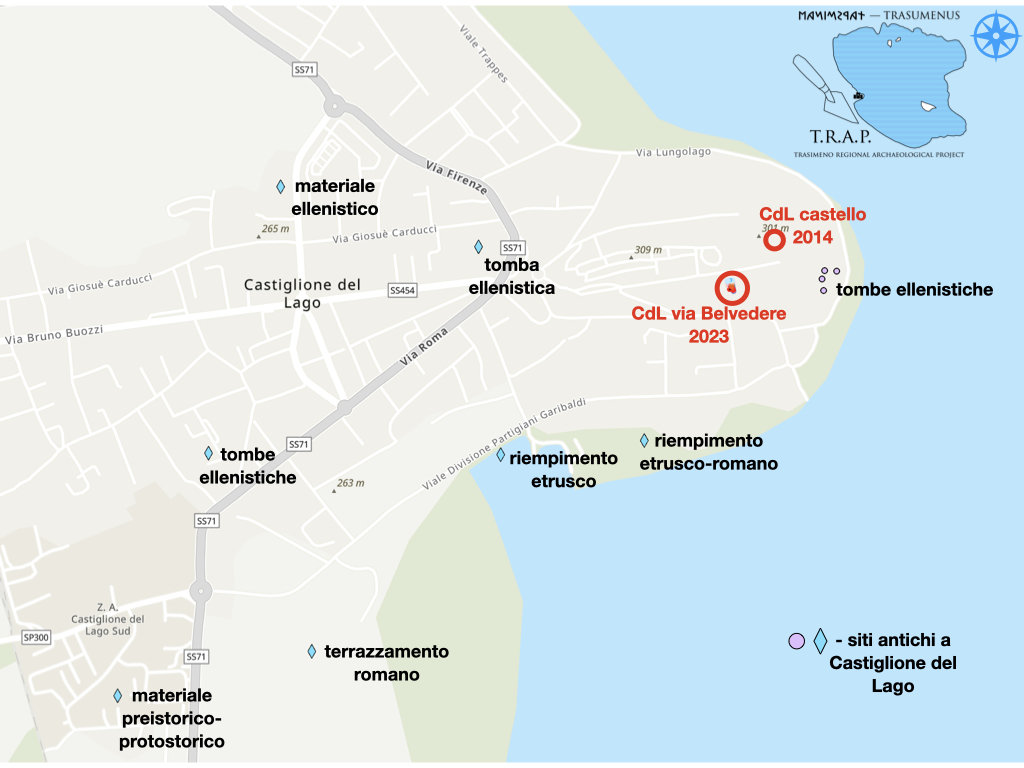
The Roman structures on the south slope of the promontory are the only clear evidence of Roman interest in establishing a permanent presence on the western shores of Lago Trasimeno. However, prior to the TRAP excavations, there had been no systematic effort to determine the extent of the Roman remains. In 2023, the opportunity to arose to excavate on the tract of land where “Le Buccace” is located. The site straddles the modern stairs the lead from the parking lot at the base of the slope to Via Belvedere, just outside the hospital. The present terracing of the slope dates to the late 1700s when the olive grove was established. A significant amount of fill was deposited on the slope in order to create the narrow terraces that exist today. As a result, the Roman structures above “Le Buccace” are well preserved.
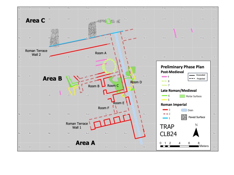
Between the 2023 and 2024 campaigns, the TRAP team investigated three levels of the site: the area between the arched wall and the drainage channel (Area A), the terrace just above the arched wall (Area B), and the third terrace up from the arched wall (Area C).
In Area A, the visible Roman walls were previously documented and published by Walter Pagnotta (1984). The east-west terrace wall (“Le Buccace”) consists of four arched recesses, which were cut into the bedrock and then faced with blocks cut in cubes, cubilia, and set in a diamond pattern called reticulatum. The outer face of the wall was also decorated in reticulatum. Perpendicular to the arched structure is a water channel that extends under the slope of the hill towards the north for at least 20 meters. The constructed part of the channel is also faced with reticulatum, however, in this case there are registers of bricks between sections of reticulatum and the end of the wall is also constructed with layers of bricks. This type of Roman construction is called opus mixtum and, in this case, we can date the walls to the late 1st century A.D. The interior of the water channel is high enough for a small adult to enter (probably to allow for cleaning). The lower segment is constructed of concrete (traces of the beams used for scaffolding are visible on the ceiling). However, as towards the upper terrace, the channel appears to have been dug out of the bedrock. Only the lower part was excavated. The floor of the channel is laid with pan tiles set to allow water to flow smoothly. The source of the water as well as the need for such a substantial channel is not yet fully understood and remains one of the key research questions for the TRAP investigations.
In 2023, the area in front of the arched terrace wall was cleaned and the accumulated sediment removed. It is clear that the Roman occupation level was higher than the present level of the terrain. While there is no evidence of permanent structures south of the arched structure, a trench dug into the natural stratum parallel to the arches, indicates that there may have been a temporary structure in the area between the arched structure and the water channel. Moreover, the base of a dolium was found in situ, below the floor level of the Roman walls. Dozens of terracotta ring weights recovered from the site provide evidence of fishing using nets. Thus, we hypothesize that the lower terrace was used for the processing and storing of food stuffs, most likely fish from the lake.
Area B, which comprises the second Roman terrace was approximately 50 Roman feet deep ( ca. 15 m.). The structures on this terrace are remarkably well-preserved due to the re-terracing of the slope in the 1700s to plant the olive trees. At that time an extra terrace was added to the Roman terraces and a significant amount of fill was dumped on top of the Roman structures in order to created those additional rows for the trees.
In Area B, there are at least six rooms and possibly a second story based on the thickness of some of the walls (Fig. 3). Like the walls below, these structures are also constructed of opus mixtum and date to the same period as the lower terrace wall and drainage channel. The walls are incredibly well preserved, despite the later activity on the site. In the earl Middle Ages, the Roman structure was still accessible and it appears that the Roman remains were used as a work-site to prepare building materials for the Medieval town, including the construction of a lime kiln in the center of Room A (see plan and Fig. 4).
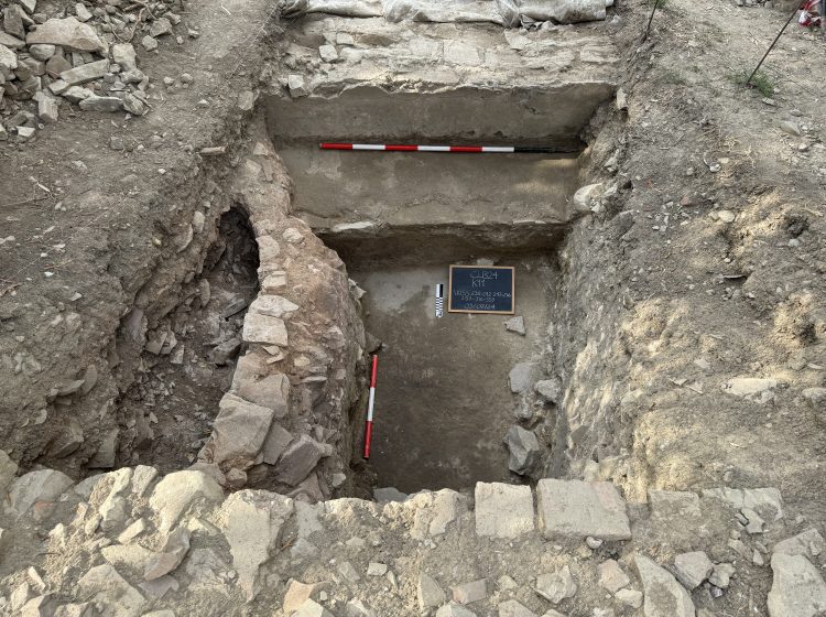
Room A, on the north side of the terrace, has been partially excavated (Fig. 4). This space was clearly used as a basin for water: the surface of the floor is composed of thick cocciopesto and at the southern end of the room, which is approximately 6 m. long, there is a low bench also coated in cocciopesto. Above the bench, the wall has a thin layer of white intonaco (which is not water-proof). The precise function of this water basin is not certain. There is evidence, for example fragments of tubuli recovered from the fill to the west of Room B, that this terrace supported a bath complex. The basin in Room A may have been part the frgidarium, however, the full extent and function of this water feature is not yet fully understood.
On the south side of Area B, the rooms are preserved to a depth of approximately 1.8 m. Inside Room E, the Roman occupation level appears to have been a dirt floor (Fig. 5). This room, and the two spaces to the west, appear to be the sub-floor of the structure and were likely used as service rooms or for storage. A stratum of carbonized wood beams above the floor in Room E indicate that the building may have burned at the end of the Roman phase.

Between the possible frigidarium and the service rooms to the south, there are at least two other rooms, B & C on the plan. Due to reuse in the early Medieval period, the Roman occupation levels in this area have not yet been reached and, as a result, the function of this area is not yet known.
The second terrace wall, which forms the north side of Room A, is preserved to a height of approximately 1.9 meters. On the level above that wall, excavations in 2023 and 2024 revealed an extensive surface comprised of selciato, that is, dark-grey cobbles. The current hypothesis is that the pavement forms a courtyard, or intermediary level of the Roman complex, marking the transition from the bath area on the lower level to residential quarters on the upper level. As of 2024, however, the northern limit of the pavement has not been determined. In 2025, the team plans to open a new excavation area further to the north to explore that hypothesis.

Finds
Very little ceramic material has been recovered from the main area of the Via Belvedere site. However, small fragments of vernice nera, impasto wares, and a few pieces of bucchero indicate that the slope had been occupied, perhaps for burials, prior to the Imperial period. One bucchero cup is well enough preserved to provide a date in the mid-6th century B.C. In 2024, in order to determine the extent of the Roman complex, a small excavation areas was opened to the east of the modern stairs. While no structures were uncovered in that area, there was a large dump of Roman cooking and dining wares, including several nice pieces of sigillata italica. It may be that the residential part of the complex is to the north east of the site.
Excavations will continue at Via Belvedere in 2025
References
Pagnotta, W. 1984. L’Antiquarium di Castiglione del Lago e L’Ager Clusinus Orientale (Archaeologia Perusina, 1), Roma.
(Page updated 11/06/25)
